km 242.43Lock
Apach Lock
Apach · FR
The southernmost lock on this stretch and the gateway to the French Moselle. Operated by VNF. From here upstream, French rules apply — among them the vignette and, where relevant…
- Fall
- 4.4 m
- Large chamber
- 175 m x 12 m
- Leisure-craft lock
- none
- Operator
- VNF — Voies navigables de France
- Bank
- right bank
Not confirmed: VHF channel. Call the harbour master before you set off.
km 242.20Landing stage
Schengen landing stage
Schengen · LU
The tripoint of Luxembourg, Germany and France, just below Apach lock. A pontoon on the Europe promenade by the three Schengen steles.
- Pontoon
- pontoon on the promenade
- Of note
- tripoint of three countries, Musée européen
km 241.96Bridge
Moselle bridge Schengen – Perl
Schengen · LU/DE
Border bridge at the tripoint, just below Apach lock.
- Air draught
- 6.63 m above HSW
- Type
- road bridge
km 241.10Bridge
Schengen Viaduct
Schengen · LU/DE
High motorway crossing of the A13/A8 between Schengen and Perl, some eight kilometres below Apach lock. No obstacle for pleasure craft.
- Air draught
- 23.70 m above HSW *
- Type
- motorway bridge
km 237.50Fuel station
Boat fuel station, Schengen Marina
Schwebsange · LU
Fuel station for boats inside the Schengen Marina basin — the only one on the Luxembourg Moselle. The installation has been renewed and again meets the required safety standards.
- Opening hours
- Monday to Saturday 10 am to 5 pm, closed on Sundays
- Note
- Times vary with the season — check with the harbour office first
Not confirmed: Welche Kraftstoffe genau angeboten werden. Call the harbour master before you set off.
km 237.50Waterside campsite
Camping Schengen Marina
Schwebsange · LU
Campsite right on the harbour basin, formerly “Camping du Port” or “De Schwebsange”. Currently being rebuilt. Some twenty to thirty pitches overlooking the harbour, with power and…
- Motorhome pitches
- 30 numbered pitches in two zones — harbour zone 1 to 14 beside the basin, bank zone 15 to 30 along the Moselle; plus a meadow zone and a preferred zone
- Shore power
- yes
- Fresh water
- yes
- Waste disposal
- Grey and black water
- Wi-Fi
- yes
- Note
- The site is being rebuilt; caravans and tents only on request to info@schengenmarina.lu
- Location
- The Route du Vin runs right past the site and industry sits on the German bank opposite — this is not a quiet spot
- Sanitary facilities
- Sanitary building with separate areas
- Food and drink
- Bistro and restaurant on site
- Bread
- Bread vending machine at the harbour
km 237.50Waste disposal
Black-water pump-out, Schengen Marina
Schwebsange · LU
Since 2023 holding tanks can be pumped out at the harbour — a step towards more sustainable operation and, so far, the only such facility on the Luxembourg Moselle.
- Accepted
- Black-water holding tanks and grey water
- Note
- By appointment with the harbour office only, not possible on Sundays
km 237.50Harbour / Marina
Schengen Marina Schwebsange
Schwebsange · LU
Der einzige Sportboothafen an der luxemburgischen Mosel und damit die zentrale Adresse für Dauer- und Gastlieger im Großherzogtum. Seit der Erweiterung 1999 stehen 220 Liegeplätze…
- Operator
- Schengen Marina (SCOP), on behalf of the commune of Schengen
- Address
- 1, Am Hafen, L-5447 Schwebsange
- E-mail
- info@schengenmarina.lu
- Berths
- 220
- Visitor berths
- 12
- Max. boat length
- 20 m
- Max. draught
- 2 m
- Shore power
- on all pontoons, 16 A — except pontoon A
- Fresh water
- on all pontoons — except pontoon A
- Pontoon A
- Pontoon A is reserved for small boats and jet skis, without power or water
- Diesel
- Fuel station on site, Monday to Saturday 10 am to 5 pm, closed on Sundays
- Waste disposal
- Pump-out for grey and black water; holding tanks by appointment only
- Mooring type
- Floating pontoons with finger docks; over 15 m along the outer mole
- Harbour office
- Daily 10:00 to 18:00 during the season
- Season
- 1 April to 31 October, seven days a week
- Winter
- From 1 November to 1 April no through traffic; wintering afloat possible, register by 1 October at info@schengenmarina.lu
- Registration
- Check-in from 14:00, check-out by 11:00. Report to the harbour master with identification and the boat’s papers; a berth is assigned
- Slipway
- yes
- Camping
- Campsite by the harbour basin, 30 numbered pitches in two zones
- Food and drink
- Restaurants and terraces close by
- Wi-Fi
- yes
- Development
- extended in 1999
- Legal form
- Cooperative (SCOP), RCS Luxembourg B294629
- Pontoon
- Eight pontoons, A to H
- Bread
- Bread vending machine at the harbour
km 237.50Slipway
Schwebsange slipway
Schwebsange · LU
Slipway inside the harbour basin. One of the few places on the Luxembourg Moselle where boats can be launched — alongside Bech-Kleinmacher, Ehnen and Grevenmacher.
- Use
- through the harbour office
- Fee
- ask at the harbour office
km 233.43Bridge
Moselle bridge Remich – Nennig
Remich · LU/DE
Border bridge immediately above the Remich landing stages.
- Air draught
- 6.70 m above HSW *
- Type
- road bridge
km 233.18Landing stage
Remich landing stage
Remich · LU
The busiest riverside promenade on the Luxembourg Moselle. Moorings for leisure boats beside the passenger-boat berths — full in summer, so arrive early. Full infrastructure…
- Pontoon
- floating pontoons along the esplanade
- Power and water
- yes
- Sanitary facilities
- nearby
- Shopping
- supermarket within walking distance
- Of note
- passenger boats, a lot of traffic
km 229.86Bridge
Bridge over the Stadtbredimus – Palzem barrage
Stadtbredimus · LU/DE
Road link across weir and lock. Passage is only through the lock chambers.
- Air draught
- no passage
- Type
- bridge over weir and lock
- Note
- weir opening not navigable
km 229.86Gauge
Stadtbredimus gauge
Stadtbredimus · LU
Luxembourg gauge at the barrage. Current readings from the flood and water-level service inondations.lu.
- Operator
- Administration de la gestion de l'eau
km 229.86Lock
Stadtbredimus / Palzem Lock
Stadtbredimus · LU/DE
The first lock on Luxembourg territory, operated by the Service de la navigation. The barrage links Stadtbredimus (LU) with Palzem (DE); a road bridge crosses the weir.
- Fall
- 4 m
- Large chamber
- 170 m x 12 m
- Leisure-craft lock
- 18 m x 3,30 m
- Operator
- Service de la navigation Luxembourg
- Bank
- left bank
- Year built
- 1964
- Reach
- 12.57 km to the next barrage upstream
- Power station
- Run-of-river power station, operated by the Société électrique de l’Our
km 229.60Mooring and waiting berth
Waiting berth Stadtbredimus lock — downstream
Stadtbredimus · LU
Official waiting berth. While waiting, keep the engine ready and the fairway clear.
- Use
- waiting berth
- Overnight stay
- no
km 229.50Landing stage
Stadtbredimus landing stage
Stadtbredimus · LU
Mooring below the barrage, handy as a waiting berth before locking through.
- Pontoon
- quay wall and pontoon
- Of note
- right beside the lock
km 224.75Landing stage
Ehnen landing stage
Ehnen · LU
A small landing stage at the historic wine village with Luxembourg’s only round church and the wine museum.
- Pontoon
- small pontoon
- Power and water
- no
km 222.15Bridge
Moselle bridge Wormeldange – Wincheringen
Wormeldange · LU/DE
Border bridge in the riesling country.
- Air draught
- 7.58 m above HSW
- Type
- road bridge
km 221.50Landing stage
Wormeldange landing stage
Wormeldange · LU
Landing stage in the centre of the riesling village, opposite Wincheringen. Places to eat right on the bank.
- Pontoon
- floating pontoon
- Power and water
- partly
km 216.60Landing stage
Machtum landing stage
Machtum · LU
Quiet wine village with a small pontoon. Little room, usually free outside the season.
- Pontoon
- small pontoon
- Power and water
- no
- Operator
- Service de la navigation
- Note
- The number reaches the administration in Grevenmacher, not a harbour master on site.
km 213.10Mooring and waiting berth
Waiting berth Grevenmacher lock — upstream
Grevenmacher · LU
Official waiting berth before the lock. For waiting to lock through only, no overnight stays.
- Use
- waiting berth
- Overnight stay
- no
km 212.83Lock
Grevenmacher / Wellen Lock
Grevenmacher · LU/DE
The second Luxembourg barrage, immediately above Grevenmacher. Waiting berths above and below; the leisure-craft lock is heavily used in season — allow for waiting at weekends.
- Fall
- 6.25 m
- Large chamber
- 170 m x 12 m
- Leisure-craft lock
- 18 m x 3,30 m
- Operator
- Service de la navigation Luxembourg
- Bank
- left bank
km 212.33Bridge
Moselle bridge Grevenmacher – Wellen
Grevenmacher · LU/DE
Border bridge at the Grevenmacher barrage.
- Air draught
- 8.39 m above HSW
- Type
- road bridge
km 212.30Landing stage
Grevenmacher landing stage
Grevenmacher · LU
Pontoons on the Moselle promenade just below the barrage. Short walk into town, with the butterfly garden and the wine cellars within reach on foot.
- Pontoon
- pontoons along the bank
- Power and water
- partly
- Slipway
- yes
- Shopping
- in the village
km 212.30Landing stage
Wellen landing stage
Wellen · DE
German bank opposite Grevenmacher, above the barrage.
- Pontoon
- pontoon
- Power and water
- partly
- Operator
- Konz municipality
- Note
- The number reaches the municipal citizens’ office, not a harbour master on site.
km 212.30Slipway
Grevenmacher slipway
Grevenmacher · LU
Ramp on the Moselle promenade, suitable for trailer boats up to medium size.
- Surface
- concrete
km 208.50Harbour / Marina
Mertert commercial port
Mertert · LU
Luxembourg’s only inland port — purely for transhipment and trade. Not open to leisure craft; please keep clear of the entrance and the basin.
- Leisure craft
- not permitted
- Operator
- Port de Mertert S.A.
km 205.90Landing stage
Wasserbillig landing stage
Wasserbillig · LU
The first Luxembourg mooring at the mouth of the Sûre, right by the village centre. A popular starting point, because Moselle and Sûre meet here. Take care when the Sûre is…
- Pontoon
- floating pontoon
- Power and water
- partly
- Shopping
- in the village
- Of note
- mouth of the Sûre, ferry to Oberbillig
km 205.70Ferry
Moselle ferry Oberbillig – Wasserbillig
Wasserbillig · LU/DE
Passenger and car ferry between Germany and Luxembourg. Ferries have right of way when crossing — keep well clear and signal your change of course early.
- Type
- car and passenger ferry
- Right of way
- watch for the ferry crossing
km 200.34Bridge
Konz railway bridge
Konz · DE
Railway bridge on the Trier–Wasserbillig line, with a footway and cycle track. The first fixed crossing above Trier lock.
- Air draught
- 6.71 m above HSW *
- Type
- railway bridge
km 200.00Harbour / Marina
Konz marina — mouth of the Saar
Konz · DE
At the confluence of the Saar and the Moselle. Starting point for a detour up the Saar to Saarburg and Mettlach.
- Visitor berths
- yes
- Power and water
- yes
- Of note
- access to the Saar
- Harbour master
- +49 176 70534589 (mobile)
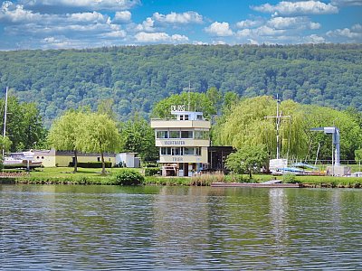
km 197.50Harbour / Marina
Trier-Monaise marina
Trier · DE
The largest harbour in the Trier basin, on the left bank at km 197.5 — above the Trier barrage and about three and a half kilometres below the mouth of the Saar. The Roman city is…
- Visitor berths
- yes
- Power and water
- yes
- Crane
- yes
- Slipway
- yes
- Operator
- Hafenverwaltung Yachthafen Trier-Monaise
- Address
- Schloss Monaise 9 + 10, 54294 Trier
- E-mail
- hafenverwaltung@yachthafen-trier.de
- Website
- https://yachthafen-trier.de
- Bank
- left bank
- Season
- 01.04. – 31.10.
- Berths
- 115
- Pontoon
- A – D
- Load capacity
- 6 t
- Sanitary facilities
- yes
- Harbour master
- yes
km 195.76Lock
Trier Lock
Trier-Euren · DE
The only barrage on the Moselle with two large chambers. From here the Moselle’s first control centre operates several locks remotely. Reach of 17.07 km.
- Fall
- 7.25 m
- Large chamber
- 170 m x 12 m and 210 m x 12.50 m
- Leisure-craft lock
- 18 m x 3,30 m
- Operator
- WSA Mosel-Saar-Lahn
- Bank
- left bank
km 195.30Gauge
Trier gauge
Trier · DE
The main reference gauge for the Upper Moselle. At flood mark I navigation is restricted; at mark II it is suspended.
- Highest navigable level
- Highest navigable water level — see ELWIS
- Marks
- Flood mark I: restrictions, mark II: navigation suspended
- Where to check
- Automatic water level announcement by the WSV
km 194.56Bridge
Konrad Adenauer Bridge, Trier
Trier · DE
Trier’s southern city bridge, barely a kilometre below Trier lock.
- Air draught
- 8.00 m above HSW *
- Type
- road bridge
km 193.15Bridge
Roman Bridge, Trier
Trier · DE
Germany’s oldest bridge still carrying traffic — Roman piers from the 2nd century, a UNESCO World Heritage Site. It is also the lowest passage on the river: the figure sits…
- Air draught
- 6.00 m above HSW *
- Type
- road bridge
km 191.69Bridge
Kaiser Wilhelm Bridge, Trier
Trier · DE
Trier’s northern city bridge, between Trier-Nord and Trier-West.
- Air draught
- 7.50 m above HSW *
- Type
- road bridge
km 187.56Bridge
Trier-Pfalzel railway bridge
Trier · DE
Railway bridge of 1878, with a footway and cycle track. The second place on the river where only the waterway minimum is clear.
- Air draught
- 6.00 m above HSW *
- Type
- railway bridge
km 183.87Bridge
Ehrang Moselle bridge
Trier · DE
Motorway crossing of the A64a at the northern edge of Trier, just above the mouth of the Kyll.
- Air draught
- 7.77 m above HSW *
- Type
- motorway bridge
km 178.10Bridge
Schweich Moselle bridge
Schweich · DE
Road bridge carrying the L 141 between Schweich and Longuich-Kirsch, reopened in 1948 after the 1906 structure was blown up. The arches are narrow and the bridge stands in a bend…
- Type
- road bridge
- Structure
- L 141
- Year built
- 1948
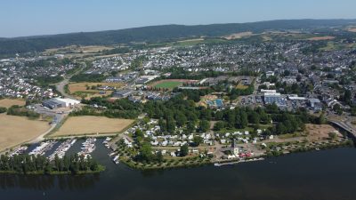
km 178.09Harbour / Marina
Schweich marina
Schweich · DE
Wassersport- & Freizeitzentrum Kreusch – your port of call on the Moselle at Schweich Right on the Moselle at Schweich, between Trier and Bernkastel-Kues, the Kreusch marina has…
- Operator
- Kreusch Gmbh & Co. KG
- Address
- Am Yachthafen 1
- E-mail
- boote@kreusch.de
- Website
- https://www.kreusch.de
- Berths
- 150
- Visitor berths
- 10
- Max. boat length
- 25 m
- Max. draught
- 1.3 m
- Water depth
- 1.3 m
- Shore power
- yes
- Fresh water
- yes
- Diesel
- yes
- Slipway
- yes
- Crane
- yes
- Workshop
- yes
- Winter storage
- Winter storage ashore
- Wi-Fi
- yes
- Sanitary facilities
- yes
- Waste disposal
- No longer available — the former pump-out station was taken out of service for lack of use
- Harbour office
- yes
- Season
- yes
km 166.18Lock
Detzem Lock
Detzem · DE
The highest barrage on the German Moselle, with a 9 m fall. When locking through, run long lines and keep them in hand — the water movement is noticeable.
- Fall
- 9 m
- Large chamber
- 170 m x 12 m
- Leisure-craft lock
- 18 m x 3,30 m
- Operator
- WSA Mosel-Saar-Lahn
- Bank
- right bank
km 141.48Lock
Wintrich Lock
Wintrich · DE
Barrage in the heart of the Middle Moselle, between Piesport and Brauneberg.
- Fall
- 7.5 m
- Large chamber
- 170 m x 12 m
- Leisure-craft lock
- 18 m x 3,30 m
- Operator
- WSA Mosel-Saar-Lahn
- Bank
- left bank
km 130.59Harbour / Marina
Bernkastel-Kues marina
Bernkastel-Kues · DE
A popular stopover harbour on the Middle Moselle, right by the old-town bank.
- Visitor berths
- yes
- Power and water
- yes
- Shopping
- in the village
- Operator
- Boots-Club Bernkastel 2000 e.V.
Not confirmed: phone, operator. Call the harbour master before you set off.
km 123.84Lock
Zeltingen Lock
Zeltingen-Rachtig · DE
Barrage below Bernkastel-Kues; a second chamber is under construction or planned.
- Fall
- 6 m
- Large chamber
- 170 m x 12 m
- Leisure-craft lock
- 18 m x 3,30 m
- Operator
- WSA Mosel-Saar-Lahn
- Bank
- left bank
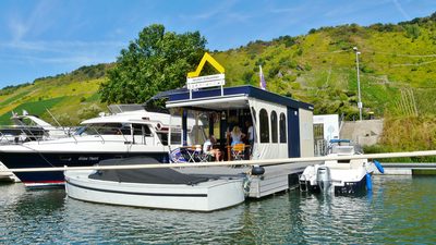
km 105.90Harbour / Marina
Boote Polch marina, Traben-Trarbach
Traben-Trarbach · DE
Marina with boatyard and fuel berth on the left bank, just downstream of the town. Visitor berths, crane, winter storage and workshop in one place — the most complete facilities…
- Operator
- Boote Polch GmbH & Co. KG
- Address
- Zum Hafen 18, 56841 Traben-Trarbach
- Website
- www.bootepolch.de
- Visitor berths
- yes
- Max. boat length
- 15 m
- Water depth
- 3,0
- Power and water
- yes
- Sanitary facilities
- WC und Dusche
- Crane
- ja, bis 20 t
- Slipway
- ja, hydraulischer Slipwagen bis 15 t
- Workshop
- yes
- Winter storage
- ja, Halle und Freiplatz, 28 € je m² (Länge über alles × Breite)
- Food and drink
- in the village
- Diesel
- ja, an der Bootstankstelle beim Ruderclub
- Petrol
- ja, Super
- Operating hours
- Mo-Fr 9-17 Uhr, Samstag nach Vereinbarung
- Note
- Die Bootstankstelle liegt einige hundert Meter entfernt beim Ruderclub und wird von Boote Polch betreut. Vor dem Tanken anrufen — erst dann fährt ein Mitarbeiter zum Anleger. Saison April bis Oktober, vormittags.
- Telefon zentrale
- +49 6541 2010
- E-mail
- info@bootepolch.de
- Season
- 1. April bis 31. Oktober
- Gastliegeplatz preis
- 2,00 € je laufendem Meter und Tag, dazu 5,00 € je Person und Nacht (Stand 2025)
- Platzvergabe
- Der Hafenmeister weist den Liegeplatz zu; ein bestimmter Platz kann nicht gewählt werden.
Sources disagree on 2 points
- Mosel-Kilometer: 105,90 laut Boote Polch und PortWiki, 106,90 laut Mosel-Touristinformation. Wir folgen dem Betreiber.
- Die Preisliste ist im Kopf mit 2025 überschrieben, traegt aber den Vermerk «Stand Maerz 2024» und im Fuss das Jahr 2024. Preise deshalb nur als Anhaltspunkt.
Not confirmed: depth, maximum length. Call the harbour master before you set off.
km 103.01Lock
Enkirch Lock
Enkirch · DE
Barrage below Traben-Trarbach.
- Fall
- 7.5 m
- Large chamber
- 170 m x 12 m
- Leisure-craft lock
- 18 m x 3,30 m
- Operator
- WSA Mosel-Saar-Lahn
- Bank
- left bank
km 78.37Lock
St. Aldegund Lock
Sankt Aldegund · DE
Barrage between Zell and Bremm, just below the tightest bend of the Moselle.
- Fall
- 7 m
- Large chamber
- 170 m x 12 m
- Leisure-craft lock
- 18 m x 3,30 m
- Operator
- WSA Mosel-Saar-Lahn
- Bank
- left bank
km 59.38Lock
Fankel Lock
Bruttig-Fankel · DE
Barrage above Cochem. Fankel houses the central control that regulates the Moselle’s impoundment levels.
- Fall
- 7 m
- Large chamber
- 170 m x 12 m
- Leisure-craft lock
- 18 m x 3,30 m
- Operator
- WSA Mosel-Saar-Lahn
- Bank
- right bank
km 51.50Harbour / Marina
Cochem marina
Cochem · DE
Stopover harbour below Reichsburg castle, busy in summer.
- Visitor berths
- yes
- Power and water
- yes
- Harbour master
- Markus Breitscheidel, mobile +49 151 54727870
Not confirmed: phone, harbour master. Call the harbour master before you set off.
km 37.11Lock
Müden Lock
Müden · DE
Barrage below Treis-Karden.
- Fall
- 6.5 m
- Large chamber
- 170 m x 12 m
- Leisure-craft lock
- 18 m x 3,30 m
- Operator
- WSA Mosel-Saar-Lahn
- Bank
- left bank
km 20.76Lock
Lehmen Lock
Lehmen · DE
The second-to-last barrage before the confluence, below Kobern-Gondorf.
- Fall
- 7.45 m
- Large chamber
- 170 m x 12 m
- Leisure-craft lock
- 18 m x 3,30 m
- Operator
- WSA Mosel-Saar-Lahn
- Bank
- left bank
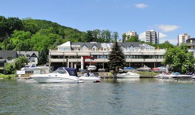
km 5.50Harbour / Marina
Wassersportzentrum Grühn
Koblenz-Metternich · DE
Marina with boatyard and chandlery on the lower Moselle at Koblenz-Metternich, upstream of the Koblenz club pontoons. Two visitor berths for boats up to 10 metres hull length…
- Operator
- Wassersportzentrum Grühn GmbH
- Address
- Winninger Straße 45, 56072 Koblenz-Metternich
- E-mail
- info@wassersportzentrum.com
- Website
- https://www.wassersportzentrum.com
- Visitor berths
- 2, auf Anfrage beim Betrieb
- Max. boat length
- 10 m
- Shore power
- 230 V am Steg
- Crane
- yes
- Workshop
- yes
- Winter storage
- ja, Halle und Freifläche
- Operating hours
- Mo–Fr 9:00–17:00 Uhr, Mi 13:00–17:00 Uhr, Sa 9:00–13:00 Uhr
- Of note
- Zubehörgeschäft und Bootshandel (Sea Ray, Boston Whaler, Olympic)
Not confirmed: Mosel-Kilometer, Lage der Steganlage, Wasser am Steg, Sanitär. Call the harbour master before you set off.
km 1.94Lock
Koblenz Lock
Koblenz · DE
The last lock before the Deutsches Eck. The fall depends on the Rhine level and varies considerably.
- Fall
- 4.7 m
- About the fall
- depends on the Rhine level, 4.70–5.30 m on average
- Large chamber
- 170 m x 12 m
- Leisure-craft lock
- 18 m x 3,30 m
- Operator
- WSA Mosel-Saar-Lahn
- Bank
- left bank

